Understanding the Hurricane Forecast Cone: Essential Insights for 2025
As hurricane season approaches, understanding the hurricane forecast cone is crucial for residents living in susceptible regions. The cone not only helps in anticipating the storm’s path but also ensures individuals are well-prepared for possible impacts.
What is the Hurricane Forecast Cone?
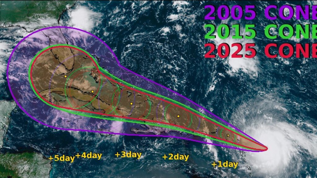
The hurricane forecast cone, introduced in 2002, serves as a visual representation of the probable track of a storm’s center. Currently, it shows a 66% chance that the storm will remain within its boundaries. This means there is also a 33% chance the storm’s center could veer outside the cone. Understanding this nuance is essential for accurate storm tracking.
Key Distinctions to Know:
- Center of the Storm: The cone indicates where the center will likely be, but it does not predict the extent of impacts like storm surge or damaging winds, which can affect areas outside the cone.
- Misconceptions: Many people mistakenly believe that all storm-related effects will occur within the cone. This is not true. The cone is simply a guide.
Improvements in Forecasting
Recent advancements have led to smaller and more accurate hurricane forecast cones. In fact, the cones for 2025 are expected to be 3% to 5% smaller compared to those from previous years. This reduces uncertainty regarding where the storm might make landfall.
- Accuracy Gains: Between 1990 and 2015, track errors were reduced by about 70%. In 2024, the National Hurricane Center (NHC) recorded its best forecast performance in history.
How to Read the Cone Effectively
To fully leverage the forecast cone, consider the following guidelines:
- Stay Informed: Regularly track updates, as the cone adjusts based on the average forecast error from the past five years.
- Understanding Wind Reach: In 2017, enhancements to the cone included shaded areas showing the reach of tropical storm and hurricane-force winds, better indicating the potential impact zones far from the center.
- Avoid Sole Focus on the Centre Line: As Brian McNoldy from the University of Miami aptly put it, “Nothing magically happens at the edge of the cone.” Keep an eye on the broader area for storm-related hazards.
The Evolution of the Cone
- Introduction: The forecast cone was designed to better communicate storm track information to the public.
- Visual Changes: The removal of the central "skinny black line" highlighted the importance of looking beyond the center track, encouraging a broader perspective on hazards.
Preparing for Hurricane Season: What You Need to Know
As the season kicks off, consider these essential preparation tips:
- Know Your Evacuation Zone: Familiarize yourself with local evacuation routes and zones to ensure prompt action when needed.
- Create a Supply Kit: Stock up on supplies like non-perishable food, water, medications, flashlights, and batteries.
- Stay Updated: Keep an eye on forecasts and alerts from reliable sources, such as the National Hurricane Center.
Conclusion
Understanding the hurricane forecast cone is critical for anyone in hurricane-prone areas. As storms become increasingly unpredictable, keeping informed and preparing adequately are your best defenses. Remember that while forecasts have improved significantly, they still come with inherent uncertainties. Always prepare for the worst, even while hoping for the best.
For more on how to stay safe during hurricane season, visit Ready.gov.


