Understanding the Hurricane Cone of Uncertainty: A Guide for Residents
As hurricane season approaches, it’s essential for residents in coastal areas, especially in Florida, to prepare themselves and understand the tools used to predict storm paths. The hurricane cone of uncertainty has been a vital resource since its introduction in 2002, providing insights into the tracks of impending storms. However, many still misinterpret its implications.
What is the Hurricane Cone of Uncertainty?
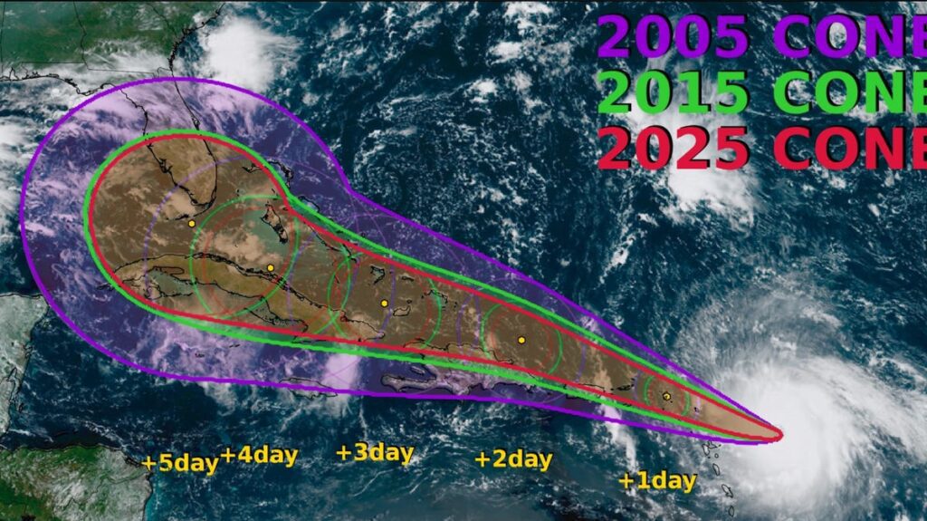
The hurricane cone represents the probable path of a storm’s center, showing where it is expected to move. Key points to understand include:
- 66% Accuracy: The center of the storm is expected to stay within this cone two-thirds of the time.
- Misinterpretations: Many believe that all storm impacts, such as winds, surge, and flooding, will occur strictly within the cone. This is not the case. The potential impacts can extend well beyond its boundaries.
Illustrating the Cone’s Limitations
- Cone Example: A smaller cone indicates reduced uncertainty regarding where a storm will strike. This year’s cone is 3% to 5% smaller compared to 2024’s.
- Impact Zones: Storm surge and high winds can affect areas outside the cone’s confines.
Brian McNoldy from the University of Miami emphasizes, “Nothing magically happens at the edge of the cone.” Understanding the cone is crucial, but fixed focus on its borders can lead to complacency.
Improvements in Hurricane Forecasting
Decades of progress in tropical cyclone forecasting have resulted in more precise track cones. Recent advancements are noteworthy:
- Significant Reductions in Errors: Tracking inaccuracies dropped by 70% between 1990 and 2015. For instance, the 3-day track error decreased from 229 nautical miles in 2000 to just 67 nautical miles in 2024.
- Challenges Ahead: Despite improvements, experts like John Cangialosi stress that further enhancements are becoming increasingly challenging due to the unpredictable nature of weather systems.
How to Prepare Before a Hurricane Strikes
Knowing your evacuation routes and safe zones is crucial. Here are some preparation tips to bolster your readiness:
- Stay Informed: Regularly monitor forecasts from reliable sources like the National Hurricane Center.
- Understand Evacuation Zones: Familiarize yourself with evacuation zones in your area.
- Storm Preparedness Kit: Create a disaster supply kit including food, water, medications, flashlights, and important documents.
Visual Representation

The Evolution of the Cone
Originally designed for better public communication regarding storm paths, the cone has undergone several refinements:
- Graphics Updates: The National Hurricane Center updated the cone to include shaded areas that indicate the reach of tropical storm-force winds, enhancing public understanding.
- Focus Changes: The central line representing the storm’s path was removed from initial graphics, responding to public misconceptions that it defined exact tracks.
Conclusion
As the next hurricane season unfolds, understanding the cone of uncertainty becomes vital for coastal residents. The advancement in forecasting tools and methods can greatly assist in preparing for storms, but awareness and education on interpreting these forecasts are just as crucial.
For future storms, remember to:
- Stay proactive
- Regularly check accurate forecasts
- Make informed decisions based on comprehensive information
By maintaining awareness and preparedness, residents can better navigate the uncertainties of hurricane season. For further resources and guidance on storm preparedness, visit Ready.gov.


